The SCOOP community currently engages in distributed coastal modeling across the southeastern US, including both the Atlantic and Gulf of Mexico coasts. Various coastal hydrodynamic models are run on both an on-demand and operational (24/7/365) basis to study physical phenomena such as wave dynamics, storm surge and current flow. The computational models, include4 Wave Watch 3 (WW3), Wave Model (WAM), Simulating Waves Nearshore (SWAN), ADvanced CIRCulation (ADCIRC) model, ElCIRC, and CH3D. In the on-demand scenario, advisories from the National Hurricane Center (NHC) detailing impending tropical storms or hurricanes trigger automated workflows consisting of appropriate hydrodynamical models. The resulting data fields are analyzed and results are published on a community portal, and are also distributed to the SCOOP partners for local visualization and further analysis, as well as being archived for further use in a highly available archive 5.
This article describes the technologies and procedures used for on-demand ensemble workflows that are used for predicting hurricane impacts, including urgent and prioritized workflows, local policies for compute resources, and providing access to urgent compute resources.
Hurricanes develop in warm ocean waters as an area of low pressure, which turns into a tropical storm as the circular wind motion becomes organized. As the wind speed picks up and crosses 74 mph, the storm is classified as a Category 1 Hurricane. Hurricanes typically take around 3-5 days to develop. Coastal modelers begin running models and providing projected hurricane tracks as soon as there is indication that an area of low pressure will turn into a storm. The National Hurricane Center (NHC) consolidates these various model runs and publishes a predicted storm track based on experience and historical data. These model predications are also coupled with data from real observations, such as the data provided by the hurricane hunter aircraft, and the published track is revised. Models are run every few hours with new information about position, central pressure, wind speeds etc. and the tracks are updated. This updated data is released to the community via advisories. The NHC publishes an advisory every six hours for every area of interest. The track data is picked up as soon as it is available and coastal scientists use this to run other wave, surge and inundation models.
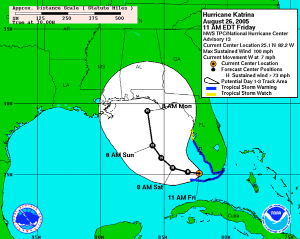
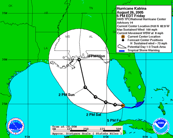
Since the NHC issues an advisory every six hours during a storm event, modelers have a six hour window in which to generate all the results based on the previous advisory and use the results to “hot start” the next runs with data from the next advisory. Figure 2 shows the tracks for the 13th and 14th advisories issued by NHC at 11AM EDT and 5PM EDT, respectively, on August 26, 2005 during Hurricane Katrina. The images highlight that there can be considerable difference in projected paths between advisories. It is believed that the necessary lead time for evacuation is 72 hours and accurate predications about the impact of the storm are dependent on the accuracy of the storm track. Hence the only way to overcome the inaccuracy in track prediction in order to provide reasonable guarantees of the predictions is to use ensemble modeling.